Peatlands are among the world’s most vital carbon stores and play a crucial role in climate regulation. But when they’re drained, they lose their carbon sink potential and unique biodiversity and contribute to climate change. In Ireland, peatland drainage for agriculture and industry has shaped the landscape for centuries. Now, as part of national efforts to combat climate change, restoration of these ecosystems is a top priority.
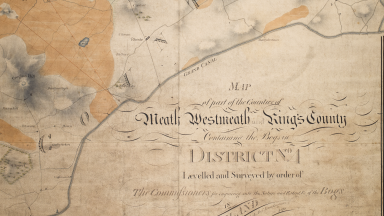
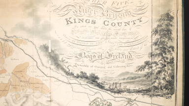
To support this goal, the RePEAT project — a collaboration between historians, geographers, and ecologists — is reevaluating Ireland’s peatlands through historical maps. By digitising and analysing the early 19th-century Bog Commission maps, which were originally created to facilitate the drainage of Ireland’s bogs, researchers can reconstruct the extent of peatlands before industrial intervention. This allows for new insights into land use, climate impacts, and potential restoration pathways.
The National Library of Ireland (NLI), which holds the original hand-drawn maps from the Bog Commission, is hosting the RePEAT: Reimagining Ireland’s Peatlands in Precarious Times temporary exhibition throughout February. As part of this, an event on Thursday, 6 February 2025, from 5:00 PM to 7:30 PM in the NLI’s Joly Theatre will bring together experts to discuss the intersection of history, science, and ecology.
The evening will feature:
- Insights into the digitisation of the Bog Commission maps and their importance in ecological research.
- A presentation by EPA/NLI Photographer-in-Residence Paula T Nolan on her project ReViewing Ireland: A Photo Study of Ireland’s Environment, which offers a fresh perspective on the Irish landscape.
- A panel discussion and Q&A session on Ireland’s peatland history and future.

Map of Bogs District Number Four: Meath, Westmeath and Kings County (Offaly) by J.A. Jones for the Commission; NLI Call Number: 16.D.19
The Irish Bogs Commission and Their Work
The story of Ireland’s peatlands cannot be told without understanding the Irish Bogs Commission, established in 1809 by the British Parliament
During the early 19th century, as the British Empire was embroiled in the Napoleonic Wars, it turned to Ireland’s landscape to address shortages in food and fabric. The Bogs Commission was formed by order of the United Kingdom’s Parliament to examine the possibility of draining Ireland’s wetlands for agricultural expansion.
Led by the prominent engineer General Charles Vallency, the Commission was composed of many members of the Royal Dublin Society, whose interests included the economic and industrial development of Ireland. The Commission recruited ten engineers to survey the island, working with teams of men and dividing Ireland into Districts for systematic study.
Notable among the engineers were:
Richard Griffith, son of Commissioner Richard Griffith, who was responsible for surveying the Bog of Allen, the River Suck, Northwestern Mayo and the Dublin and Wicklow Mountains. His roll of payments and expenses during surveying is the only surviving record of all the engineers; it can now be found in the NLI’s collections.
Richard Lovell Edgeworth, an engineer and inventor, as well as the father of famed author Maria Edgeworth. His work for the Commission was primarily conducted along the Upper Shannon and its tributary, the Inny, which flowed past his estate in Edgeworthstown, County Roscommon. The Edgeworth Papers, relating to both father and daughter, can be accessed in microfilm form through the National Library.
John/James Alexander Jones, whose work on the then recently completed Grand Canal saw him assigned District 4, the Upper Boyne, which comprised Westmeath, Meath and parts of Offaly.
Alexander Nimmo, the Scottish engineer who was assigned the mountainous areas of Kerry and Connemara to survey and chart. He would later construct what is now Sarsfield Bridge in Limerick City.
John Longfield, a professional land surveyor operating from Grafton Street, whose company created the maps that now form the National Library’s Longfield Maps Collection, much of which has been digitised. These maps date from 1770 to 1840. Longfield operated in District 5 for the Commission, then known as King’s County, now County Offaly.
Their colleagues included Thomas Townshend, Richard Brassington, David Aher, Thomas Colbourne and William Bald.

